Experimental Facilities
The Institute of Ionosphere possesses a developed and modern research infrastructure, including a high-altitude cosmic ray station, the “Orbita” radio testing ground, a geomagnetic observatory, and a local GPS (CORS) network:
The “Alma-Ata” Geomagnetic Observatory is located at an altitude of 1,300 meters above sea level in the foothills of the Tien Shan, approximately 10 km from Almaty. Its geographical coordinates are [$43.10^\circ \text{N}$; $76.57^\circ \text{E}$], and its geomagnetic coordinates are [$34.3^\circ \text{N}$; $152.7^\circ \text{E}$]. The observatory conducts continuous monitoring of the geomagnetic field, including the $X$, $Y$, and $Z$ components of the geomagnetic field vector and the total field intensity $F$. Measurements are carried out in accordance with the INTERMAGNET Manual and standards. The following equipment is used at the geomagnetic observatory:
- fluxgate magnetometer LEMI-008;
- portable single-axis magnetometer; LEMI-203;
- Overhauser magnetic sensor POS-1.
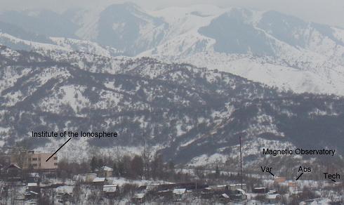
At the end of 2005, the “Alma-Ata” Geomagnetic Observatory was awarded a certificate of quality by the International Organization INTERMAGNET.
Data from the “Alma-Ata” Geomagnetic Observatory is available on the observatory’s webpage.
At the “Orbita” high-altitude radio testing ground (2,700 m above sea level), located near Almaty, the following systems are installed and operational:
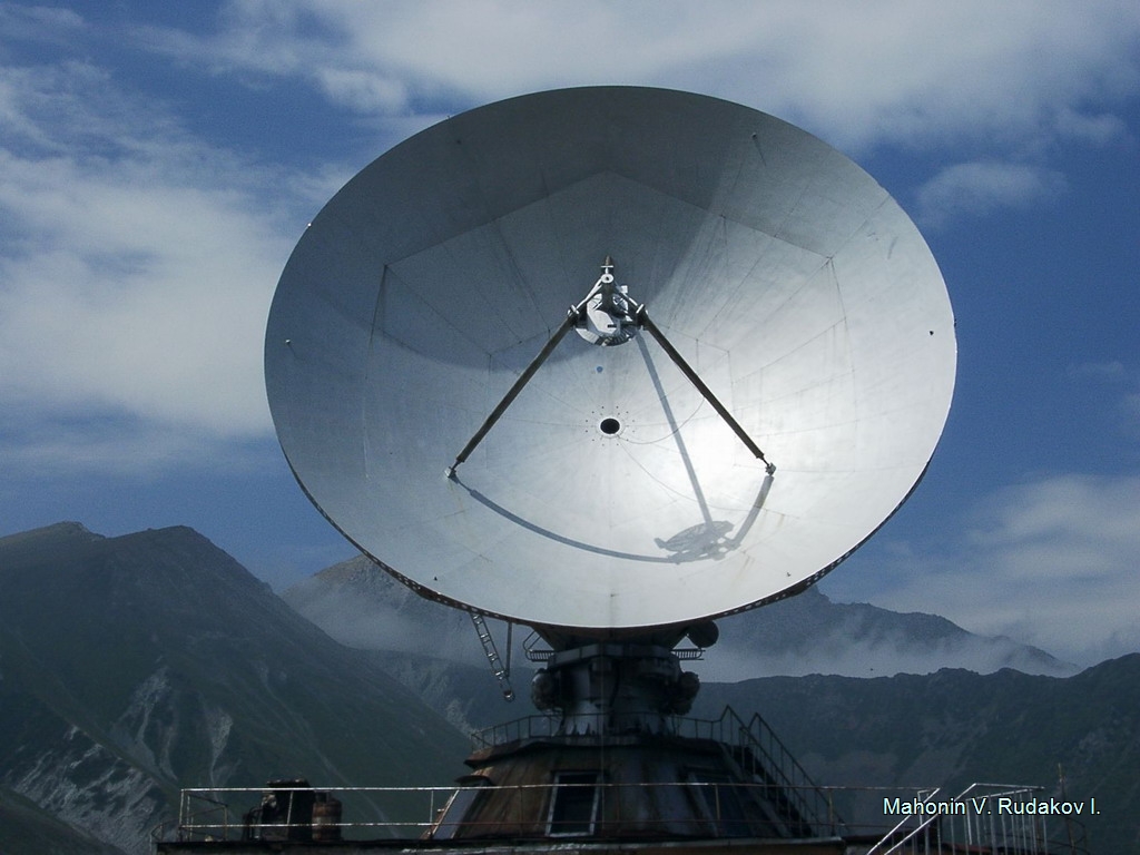
- Radio telescope TNA-57, 12-meter diameter parabolic radio telescope;
- equipment for recording solar radio emission at frequencies of 1 GHz and 2.8 GHz, and a Callisto solar radio spectrograph (part of the international e-Callisto network). The Callisto solar radio spectrograph enables the recording of Type II, III, IV, and V solar radio bursts and the forecasting of the geoeffectiveness of solar flare activity (“Orbita” Radio Testing Ground, 2,750 m above sea level);
- the SATI (Spectral Airglow Temperature Imager) optical instrument, used for spectrophotometric measurements of temperature, as well as hydroxyl and molecular oxygen emissions in the mesopause region;
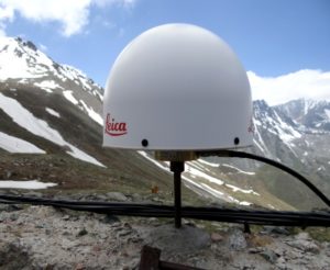
- stationary GNSS receiver used to study variations in the ionospheric Total Electron Content (TEC).
Using the data obtained from these instruments, along with data from corresponding global networks of similar stations, enables analysis of atmospheric variations caused by powerful catastrophic geophysical events occurring anywhere in the world.
At the Tien Shan High-Altitude Scientific Station (TSHASS, 3,340 m above sea level), the following installations are operational:
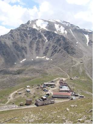
- 18NM-64 neutron supermonitor (3,340 m above sea level, geomagnetic cutoff rigidity $R = 6.7$ GV). It has been in continuous operation since 1973. The institute’s cosmic ray station (international designation: AATB), equipped with this neutron monitor, is one of the key locations in the global network of stations. Experimental data is provided in real-time on the institute’s website. The station is a member of the international Neutron Monitor Database ( NMDB, www.nmdb.eu ), to which cosmic ray intensity and atmospheric pressure data are transmitted every minute. Measurements taken with the neutron monitor, along with the software, data processing methodologies, and hardware, are constantly modernized and comply with international standards;
- BRS-1 atmospheric pressure sensor (3,340 m above sea level);
To solve problems related to the study of earthquake preparation processes, a multi-parameter experimental complex (headed by N.M. Salikhov, PhD in Physics and Mathematics) is operational near the epicenters of the catastrophic Verny and Kemin earthquakes:
- gamma-ray detector with a NaI(Tl) sodium iodide crystal, SDN.30, Ø40mm – measuring variations in gamma-ray flux intensity in a borehole at a depth of 39 m (“Cosmostation”, 3,340 m);
- BDEG2-39 gamma-ray detector with a NaI(Tl) sodium iodide crystal, Ø 150mm – measuring variations in gamma-ray flux intensity in the surface atmosphere (“Cosmostation”, 3,340 m);
- temperature sensors (4 units), installed in a borehole at depths of 1 m, 24 m, and 39 m, as well as in the open air near the borehole;
- high-sensitivity acoustic microphone (25 Pa/mV) for recording seismo-acoustic emissions in a borehole at a depth of 52 m;
- hardware-software complex for recording electromagnetic field variations in the ultra-low frequency (ULF) range, installed near the “Cosmostation” (~3,450 m above sea level);
- hardware-software complex for recording electromagnetic fields within the Earth-ionosphere spherical waveguide in the VLF frequency range (sferics), installed near the “Cosmostation” (3,700 m above sea level);
- hardware-software complex for recording the Doppler frequency shift of ionospheric signals in the HF range over the epicenters of catastrophic earthquakes (“Orbita” Radio Testing Ground, 2,750 m above sea level);
- ISGM03 precision microbarograph for recording infrasonic waves in the range from fractions of a Pa up to 100 Pa (“Orbita” Radio Testing Ground, 2,750 m above sea level);
- electrometer for recording induced electricity from charges in the surface atmosphere and the electromagnetic component caused by the movement of charges (“Orbita” Radio Testing Ground, 2,750 m above sea level).
The Kazakhstan multi-level experimental complex, in conjunction with measurements from space observatories and satellites, enables the diagnostics of the near-Earth space environment and the forecasting of hazardous space weather periods that affect satellite operations, aviation, communication, and navigation systems. The laboratory hosts the Near-Earth Space Environment Diagnostics Sector, which provides daily geomagnetic and radiation environment forecasts.
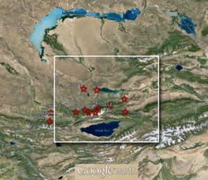
Local GPS network
Since 2009, the first phase of a GPS network has been established and operational, consisting of 5 proprietary and 5 leased receiving stations operating in continuous observation mode. This network was created within the framework of the Republican Budget Program 002, “Applied Scientific Research in the Field of Space Activities.” The GPS receiver types include Leica GRX1200GGPRO, TurboRogue SNR 8000, Trimble 4000SST, and Ashtech Z18. The GPS receiver network is integrated with the ground-based seismic station network of the Institute of Seismology within the Almaty Forecasting Testing Ground. Modern versions of the licensed GAMIT/GLOBK software suites are utilized for primary GPS data processing. Additionally, a software package has been developed for the interpretation and visualization of GPS observation results, as well as for determining calculated parameters of displacement fields and stress-strain state elements of the Earth’s crust.